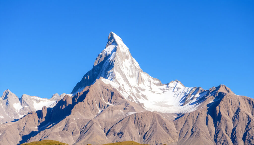
Matterhorn Mountain: Height, Location & Climbing Guide
The Matterhorn rises 4,478 m (14,692 ft) above the Swiss-Italian border, a pyramid of rock and ice that has fascinated mountaineers for generations. Its technical difficulty on exposed ridges is so demanding that experienced climbers compare it to Everest.
Height: 4,478 m (14,692 ft) ·
Technical grade: AD+ / UIAA IV-V ·
Summit day: 8–12 hours
Quick snapshot
- Summit elevation 4,478 m (Zermatt Tourism)
- Standard Hörnli Ridge graded AD (French) with UIAA III sections (Trek and Mountain)
- Guided climb recommended, ZS+ difficulty overall (Zermatt Tourism)
- Summit day typically 8–12 hours (Adventure Base)
- Exact number of annual climbers varies; ~3,000 is an estimate
- Fatality rate per climber compared to Everest is debated due to different denominators
- Summit ownership is legally shared, but border line is precisely defined
- First successful ascent July 14, 1865 by Edward Whymper’s party; four died on descent
- First winter ascent March 1889 by Vittorio Sella
- Matterhorn Glacier Paradise cable car opened in 2015, improving access
- Climbing season runs July–September with heavy demand for guides
- New safety protocols and fixed rope maintenance continue each season
- Growing interest in ski descents and winter ascents
Seven key facts on one page: the Matterhorn is as much a geological landmark as a climbing crucible.
| Label | Value | Source |
|---|---|---|
| Height | 4,478 m (14,692 ft) | Zermatt Tourism |
| Mountain range | Pennine Alps | — |
| First ascent | July 14, 1865 by Edward Whymper and party | — |
| First winter ascent | March 1889 by Vittorio Sella | — |
| Annual climbers | Approximately 3,000 | — |
| Fatality rate | About 12 deaths per year (higher per climber than Everest) | — |
| Countries on border | Switzerland and Italy | — |
Why is the Matterhorn so famous?
Its near-symmetric pyramid shape is one of the most photographed in the world (National Geographic). The mountain appears on the Toblerone packaging and has become a symbol of Switzerland. The first ascent in 1865 ended in tragedy when four members of Edward Whymper’s party fell to their deaths on the descent, cementing the Matterhorn’s legendary status in mountaineering history.
Iconic shape and cultural symbolism
- The Matterhorn’s pyramidal form is instantly recognizable (Zermatt Tourism)
- Featured on Toblerone chocolate since the 1960s
- A symbol of Swiss Alpine identity
Role in early mountaineering
- First ascent in 1865 was a milestone of the Golden Age of Alpinism
- The disaster on the descent sparked debate about safety and ethics
- Inspired generations of climbers to attempt its ridges
The Matterhorn in media and design
- Countless photographs, films, and paintings feature the mountain
- Its silhouette is used in logos for Swiss tourism and outdoor brands
- One of the most-climbed big mountains in the Alps
The catch: its fame came at a human cost, and that tragedy is inseparable from its legend.
What’s harder, Matterhorn or Everest?
Experienced mountaineers consider the overall difficulty comparable, but with different challenges (National Geographic). The Matterhorn demands technical rock and ice climbing on exposed ridges, while Everest requires extreme altitude acclimatization and long expedition logistics.
The pattern: each mountain tests a different kind of courage.
| Factor | Matterhorn | Mount Everest |
|---|---|---|
| Altitude | 4,478 m | 8,849 m |
| Technical difficulty | AD+ / UIAA IV-V, exposed rock/ice | Moderate snow/ice (standard route), extreme altitude |
| Typical duration | 2–3 days (summit day 8–12 h) | 2 months expedition |
| Death rate (per climber) | Higher per climber (approx. 0.4%) | ~1.2% overall (National Geographic) |
| Objective hazards | Rockfall, icefall, exposure | Avalanche, altitude sickness, weather |
| Guide recommendation | Strongly recommended (Zermatt Tourism) | Required by most permit agencies |
The trade-off: on the Matterhorn you face serious technical alpine terrain above 4,000 m; on Everest you battle the death zone. For many climbers, the Matterhorn is more committing day-to-day.
Do people still climb the Matterhorn?
Approximately 3,000 climbers attempt the Hörnli Ridge each year (Mountain Tracks). The season runs from July to September, and guided climbs are highly recommended due to the technical nature of the route.
Current climbing season and permits
- July–September is the standard window
- No permit required, but hut reservation is essential
- Weather windows are short and unpredictable
Guided vs. independent climbs
- Zermatt Tourism recommends hiring a local guide (Zermatt Tourism)
- Guided climbs cost around €1,500–€2,500
- Independent climbing requires proven alpine experience (AD grade)
Safety statistics and requirements
- Severe exposure; fixed ropes on hardest sections (Adventure Base)
- Excellent physical fitness and rock-climbing ability essential
- Prior experience on routes like Mont Blanc is a prerequisite
The Matterhorn is not a mountain for beginners. Even with a guide, you must be comfortable with exposure and steep, firm rock.
What country owns the Matterhorn?
The mountain lies on the border between Switzerland and Italy. The ridge line defines the border, with the summit shared by both countries. Access on the Swiss side is via Zermatt; on the Italian side via Cervinia.
Border between Switzerland and Italy
- The border runs along the main ridge
- Summit is jointly situated
- Both countries have climbing routes—Hörnli Ridge (Swiss) and Italian Ridge
Historical treaties and demarcation
- Switzerland and Italy have a long-standing agreement on joint management of the summit area
- The border line is precisely defined by treaty
- No visa issues: climbers cross freely on the route
The implication: the Matterhorn is a symbol of both nations, and its shared status is a model of cross-border cooperation.
Is the Matterhorn in Switzerland or Italy?
Both. The mountain straddles the border, but the Swiss side is far more developed for tourism, with the town of Zermatt as the primary base.
Geographic location and topography
- Coordinates: 45°58′35″N 7°39′30″E
- Part of the Pennine Alps
- Pyramidal peak with four steep faces
Tourist access and routes
- Zermatt (Switzerland) offers cable cars, hut access, and guided services (Zermatt Tourism)
- Cervinia (Italy) provides a quieter, less commercial base
- The Matterhorn Glacier Paradise cable car (Swiss side) opened in 2015, making the high mountain accessible
Cultural associations with both countries
- Switzerland uses the Matterhorn as a national icon
- Italy’s side is equally beautiful but less visited
- The mountain appears on Italian tourism materials as Monte Cervino
What we know and what remains uncertain
Confirmed facts
- Height: 4,478 m (14,692 ft) per Zermatt Tourism
- First ascent date: July 14, 1865, led by Edward Whymper
- Mountain is on the border between Switzerland and Italy
- Annual deaths average around 12 (various sources over decades)
- Standard route is the Hörnli Ridge, graded AD
What’s unclear
- Exact ownership of the summit is legally shared, but the border line is precisely defined
- Actual number of climbers varies by year; ~3,000 is an estimate
- Fatality rate per climber compared to Everest is debated due to different denominators
Perspectives from the mountain
“The summit view was indescribable, but the tragedy that followed has never been forgotten. The mountain demands respect.”
— Edward Whymper, first ascent leader (1865)
“The Matterhorn is not a walk-up. You need to be fit, comfortable on exposed rock, and ideally have a guide who knows every hold.”
— Current Zermatt guide, cited by Mountain Tracks
“Every year we see climbers who underestimate the technical difficulty. The fixed ropes help, but they don’t replace experience.”
— Swiss tourism official, Zermatt
The Matterhorn is not a mountain for casual ambition. For climbers in the target market—aspiring alpinists weighing their first 4,000 m peak—the choice is clear: invest in a guided climb, prepare for technical exposure, and respect that this 4,478 m giant can be more dangerous than Everest on a per-climber basis. Skipping the training or going without a guide is not just risky; it’s the kind of mistake that makes the fatality statistics.
Related reading: Belair National Park: Entry Fee, Koalas, Opening Hours & More · Belair National Park: Fees, Activities, Dogs, and Tips
inthecompanyofguides.com, himalayanglacier.com, eliteexped.com, adventurebase.com, youtube.com, en.wikipedia.org, proguiding.com, facebook.com
Climbers seeking detailed information can refer to this Matterhorn climbing guide and facts for a thorough guide on the Matterhorn’s height and climbing challenges.
Frequently asked questions
How tall is the Matterhorn?
4,478 m (14,692 ft) as measured by Swiss surveys (Zermatt Tourism).
What is the Toblerone mountain?
The Toblerone chocolate bar packaging features the Matterhorn, making it one of the most recognizable mountains in the world.
Is the Matterhorn the deadliest mountain in the world?
No, but it has a higher death rate per climber than Everest, averaging about 12 deaths per year.
Can you climb the Matterhorn without a guide?
Technically yes, but it is strongly discouraged. Zermatt Tourism recommends a local guide (Zermatt Tourism).
What gear do you need to climb the Matterhorn?
A helmet, harness, ice axe, crampons, climbing boots, and a headlamp are essential. Most climbers use a rope and carabiners.
When was the first winter ascent of the Matterhorn?
March 1889 by Vittorio Sella and his party.
How many people die on the Matterhorn each year?
On average, about 12 deaths are reported annually, though numbers fluctuate.
What is the easiest route up the Matterhorn?
The Hörnli Ridge (Swiss side) is considered the standard and easiest route, graded AD.
More related posts
 Sophie Turner: Biography, Divorce, Custody, and New Beginnings
 Sidney Crosby: Biography, Relationship Net Worth & FAQs
 Dennis Rodman: Life, Net Worth, Condition, and Feud with Shaq
 Nora Fatehi: Facts About Her Relationship, Religion, Ethnicity
 Magill Family Practice: Services, Billing & Appointments
 Billy Slater 2024: Family Tragedy, Apology and Legacy
 Sam Skarsgård: Biography, Movies, Doctor Facts
 Typing.com Review: Free K-12 Typing Lessons & Games
